backcommunication medium
PhD Thesis (TU Wien)Abstract
Floods are the most costly natural disaster worldwide, causing significant socio-economic losses. There is a growing concern that floods are increasing in frequency and magnitude due to climate change. In order to mitigate the disastrous consequences, flood management agencies, regional planners, and insurance companies rely on an accurate modeling of inundated areas. The reliability of large-scale flood hazard maps, which show the probability of flooding at a specific location within a certain time period, is of key importance. Previous large-scale studies show limitations in terms of accuracy and local relevance in the delineated inundation maps. The aim of this thesis is to develop accurate and efficient methods for fluvial and pluvial flood hazard assessment at large scales.
In a first step, the focus is on the numerical scheme for solving the instationary two-dimensional shallow water equations (SWEs). In the SWEs, the bed source term accounts for the gravitational acceleration due to a sloped bed. In finite volume methods, the treatment of discontinuities in the bed source term across cell interfaces is challenging. To address this issue, a second-order accurate scheme is developed based on a recently introduced first-order accurate scheme. The novel scheme involves a specialized reconstruction of water levels and bed levels enabling an accurate resolution of shallow flows over abruptly changing bed topography. The scheme's accuracy is verified with analytical solutions in several Riemann problems and the parabolic basin test case, and it is shown to outperform previous schemes. The scheme is also validated on historic flood events in Malpasset, France, and Lobau, Austria, showing good agreement between simulated and observed water level records.
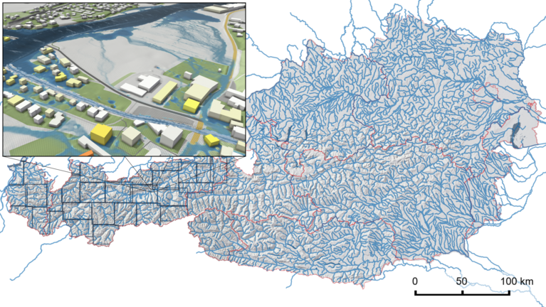
Second, the presented second-order scheme is applied in an inundation modeling framework for Austria at a resolution of 2 m. Given an arbitrary tiling of the region of interest, the framework automatically sets up boundary conditions and executes the hydraulic simulation. For an efficient simulation, discharges are adjusted along the 33,880 km long stream network to maintain the prescribed flood probabilities. In combination with a parallelized implementation running on 10 graphics processing units (GPUs), the delineation of an inundated area of 3500 km² for a 100-year flood takes less than a month. The approach shows good agreement between simulated and measured data at stream gauges, as well as between simulated inundated areas and local flood hazard maps, achieving a critical success index (CSI) score of 0.7.
Third, an integrated modeling framework is proposed that accounts for processes relevant for flash floods. Interception and infiltration is modeled in a time-dependent, spatially distributed way. For urban scenarios, the surface flow is coupled with the sewer network in an interleaved way, which allows parallel time-stepping. Except for the sewer network simulation, all models are implemented on a GPU, resulting in runtimes up to 1000 times faster than a sequential execution on a central processing unit (CPU) core. For rainfall--runoff modeling, the first-order accurate scheme at a higher resolution is more efficient than the novel second-order accurate scheme at a lower resolution. The coupled model is able to accurately simulate areas of up to 200 km² with a resolution of 1 m.
Overall, this thesis contributes to current research on large-scale flood hazard mapping through innovative methods with enhanced accuracy and computational efficiency.
research topic
research groups
solutions