Former projects

Contact

Dipl.-Ing. Dr. Christoph Traxler

Area Coordinator Smart Worlds & Head of GeoSMAQ, Geospatial Visualization, Semantic Modelling, and Acquisition Group

traxler(at)vrvis.at +43 1 908 98 92 520

Project Details

Start: 07.2018

End Date: 12.2019

Partners

Joanneum, EOX

Funded by

FFG ASAP

Use Cases

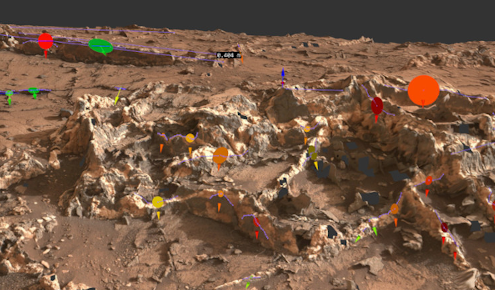
MINERVA offers the users the opportunity to visualize, analyze, and annotate the mission data in a spatiotemporal context that also considers interrelations:

  • Support scientists in geo-referencing of scientific products (e.g. spectra) for the characterization of regions and the identification of their boundaries.
  • To enable a holistic overview of products, their correlations and their distribution by time, rover orientation, etc.
  • Measure/annotate on 3D surfaces with PRo3D and share this with peers
  • Search for spatial and temporal correlations in laboratory instruments data (spectrometers etc.).
  • Get geospatial overviews of products’ locations having certain characteristics (e.g., a spectrum with a certain shape).
  • Simultaneous inspection of ensembles of spectra/images. This may include a characterization of the overall dispersion, a pairwise comparison of particular products, and the clustering of products by their characteristics (e.g., the shape of their spectrum).
  • Identify bidirectional relation of product locations to corresponding product characteristics, e.g. potentially non-contiguous regions where objects have certain characteristics.

Video Minerva

Watch this demo video on our YouTube channel to learn more about MINERVA.
By playing this video, YouTube may save personal data such as your IP address.

Related Projects