
Simulations not only help to better understand real processes, but can also change these processes in the long term through the possibility of playing through alternative scenarios and plans. This is particularly important for a comprehensive understanding and for the protection of our habitats, which is why we have been concentrating on modelling and simulating environmental processes on the basis of large geodata sets for many years. In our research work to date, we have created solutions using innovative simulations of the hydrological cycle and associated extreme events, personal simulations for evacuation scenarios and logistics models for deployment planning, which have been used in reality for many years. Since fast computing times and reliable accuracy of the simulation results are of utmost importance, we are working on the development and optimization of numerical solution methods in the field of high performance computing. We also focus on the smart integration of simulation and visualization, as this makes the presentation of results more understandable and low-threshold.

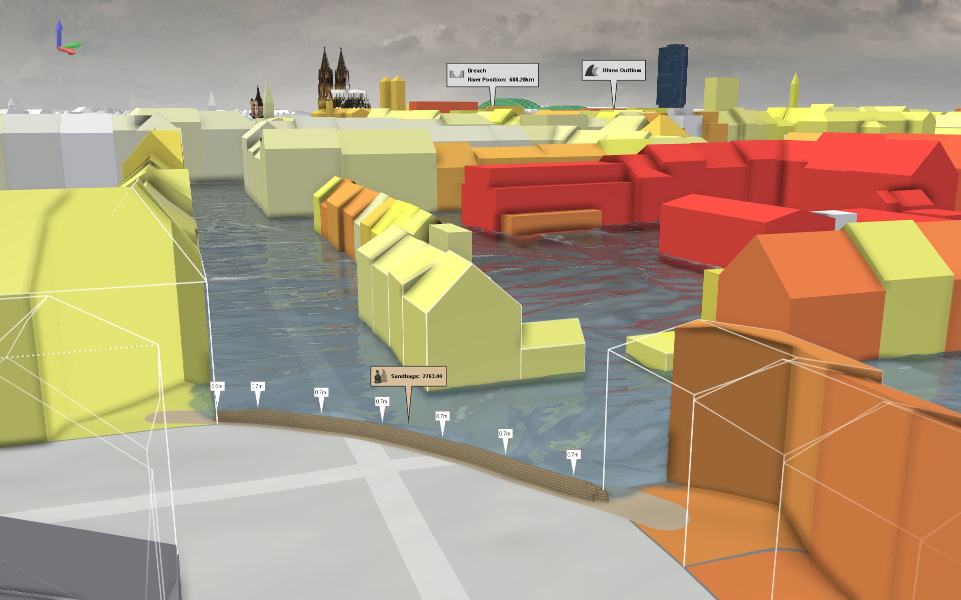
The award-winning viscloud software bundles our expertise in simulation, hydrodynamic modeling, and visualization in an easy-to-use tool that supports users in quick decision-making. At an unprecedented speed, vidcloud can simulate flood and heavy rainfall scenarios of extensive areas while also enabling analysis - for example, to define hazard zones - and 3D visualizations of the simulation results. As a proven tool in many research projects with Austrian and German cities and regions for developing heavy rainfall hazard maps and disaster management measures, another important application of viscloud lies in climate change adaptation and flood-sensitive urban planning, such as for the implementation of blue-green infrastructure and sponge city concepts.

Energy and heat consumption calculation in buildings is a complex matter that energy planners and building physicists had to do mainly manually and step by step until today. To simplify and accelerate the energy planning workflow, we are developing a customized planning tool that combines simulation with digital BIM twins and interactive visualization to give fast and tangible solutions on energy efficiency and HVAC (heating / air conditioning / ventilation) during the planning process. The BEM-based tool (Building Energy Modeling) allows one to select, calculate, and adjust all parameters for the thermal design of a building with just one click and to visualize the simulation results in an interactive 3D model.

Interactive real-time simulation of light and lighting situations allows the identification of the optimal light sources, illuminances, uniformities, etc., already in the planning process itself and thus excludes unwanted shading, glare effects, or wrong light incidence angles in the final realization. For more than a decade, we have been developing innovative lighting simulation systems for buildings and large areas, such as stadiums, in cooperation with lighting specialists working in the field. With these systems, it becomes instantly apparent how well or poorly the planned lighting scenarios work, thanks to split-second calculations and dynamic 3D visualization. In addition, the straightforward real-time interaction with the simulation by the user, a functionality we specialize in for a wide range of applications, allows light settings and scenes to be modified within seconds, thereby immediately verifying any adaptation.

Simulation of extensive spatial data increasingly relies on freely available satellite imagery, such as the European Sentinel-2 data. However, these data have a fundamental drawback: their resolution is often not fine enough to represent small-scale land parcels or specific spatial details. At VRVis, we explore innovative methods to change this using Super Resolution Reconstruction technology. In this process, existing images are AI-enhanced and, based on "image experiences" of the artificial intelligence, valuable image and texture information is subsequently restored, from which essential input parameters such as soil properties, piping, or water body boundaries can be derived for the simulation.
Bei der Simulation von großen räumlichen Daten wird immer mehr auf frei verfügbare Satellitenbilder, wie beispielsweise des europäischen Sentinel-2-Daten, zurückgegriffen. Diese Daten haben jedoch einen grundlegenden Nachteil: Ihre Auflösung ist oft nicht fein genug, um kleinteilige Landparzellen oder spezifische räumliche Details abbilden zu können. Am VRVis erforschen wir neuartige Methoden, um dies mithilfe von Super Resolution Reconstruction-Technologie zu ändern. Dabei werden existierende Bilder KI-gestützt nachgebessert und basierend auf „Bilderfahrungen“ der Künstlichen Intelligenz wichtige Bild- und Oberflächeninformationen nachträglich wiederhergestellt, aus denen dann wichtige Eingangsparameter wie Bodenbeschaffenheit, Verrohrungen oder Gewässerbegrenzungen für die Simulation abgeleitet werden können.

Simulating Eye Diseases and Vision in Virtual Reality
Visual impairment and eye diseases such as cataracts, macular degeneration, or diabetes-related visual deficits are widespread and becoming increasingly pressing issues in our aging society. To best address these challenges, a better understanding of the individual impact of impaired vision is essential. For this reason, we focus part of our research in the area of Extended Reality on the simulation and visualization of low vision and eye diseases by using virtual and augmented reality technology. Our simulation tool XREye enables physicians to better understand and consequently treat eye diseases, create more accessible public spaces, re-evaluate standards such as escape route guidance systems, and much more. More about XREye

The ClimaSens project researches efficient and easy-to-access planning tools to enable engagement across different stakeholder groups in the shaping of climate-resilient habitats.
In a research project for Rhineland-Palatinate, VRVis is creating a cooperative digital hydro twin for the German federal state to support the development of protective measures against heavy rain and river flooding.
The cities of the future rely on blue-green infrastructure: the University of Copenhagen, Henning Larsen and VRVis develop a software framework that combines hydrological modeling and 3D visualization for sponge city planning.
VRVis develops an interactive viscloud model for the OOWV (Oldenburgisch-Ostfriesischer Wasserverband) for simulating and visualizing regionally differentiated heavy rainfall events for the entire OOWV area.
As part of the research project WiCiD, VRVis is developing an interactive viscloud web application for the city of Gothenburg on behalf of DHI Sweden.
InPlan and VRVis develop a visualization and simulation package for energy planning of buildings, which enables intuitive optimization in terms of energy efficiency and comfort.
A high-resolution base model of the entire federal state of Rhineland-Palatinate makes heavy rain and flood simulations accessible to different user groups.
The Rail4Future project is focusing on the design of a digital rail system for the future. To this end, a novel and fully virtual validation platform for large-scale simulations of entire rail lines is being developed to increase the efficiency of existing rail infrastructure.
The Raincloud project's goal is to optimize and extend the simulation software viscloud to tackle the increasing challenges in water planning and disaster management in the face of climate change.
For many years we have been dealing with all aspects of hydrodynamic modelling. With our software viscloud we can model different scenarios and also offer this as a service.
We create a digital twin of a community and simulate weather events to identify high-risk buildings and infrastructure vulnerabilities.
VR and AR provide new solutions for the automotive industry, especially in the prototyping phase: Perfect digital VR twins can be used to easily check how new designs or adaptations affect the prototype.
The goal of HORA 3D is the development and maintenance of a publicly accessible web application for object-related visualization of the results of the HORA 3 research project.
viscloud's hydrodynamic simulations provide precise water level predictions at any point on a water surface in the "PegelAlarm" app.
To take full advantage of data from automotive simulations and measurements, we combine interactive and automatic Visual Computing methods to find intuitive, efficient and effective solutions that are applicable in the daily routine of engineers.
Practical flood management with decision software viscloud.
Heavy rainfall events are increasing throughout Europe. In the EU project RAINMAN, VRVis has developed an interactive viscloud model to visualize the course and consequences of possible flood scenarios caused by heavy rainfall for the city of Graz.
Digital representations of the real world and digital twins are becoming increasingly important for planning, situation assessment and decision-making.
The HORA 3 project focuses on flood modelling for all rivers and streams in Austria. The results are detailed flood risk maps for different annual periods.
Decision support system for floods and inundations for the trading district of Shenzen, China.
Flood protection through simulation and visualization: Reducing the effects of floods and communicating measures to the public.
Research and development of novel interactive visualization methods for visualization and understanding of complex systems.
High-quality lighting simulation requires dynamic, interactive, realistic real-time lighting simulation for various complex architectural environments.
Visual Analytics for Modeling and Simulation: Improvement of simulation setup and design scenarios with tools and methods of Visual Analytics.
Next generation workflows for interactive knowledge generation from images and simulations.