

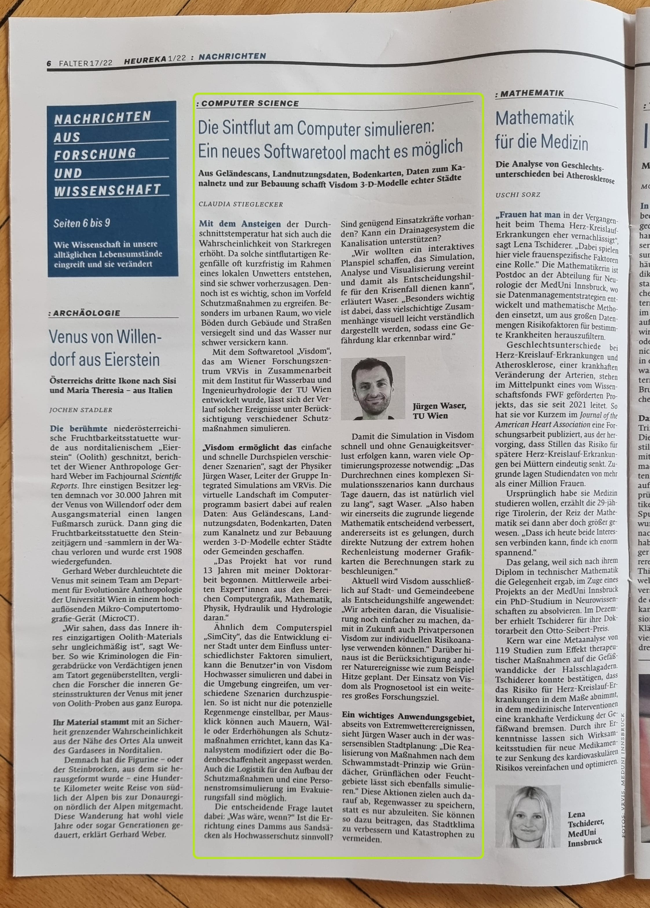
Many decision-making processes in the environmental sector use simulations of relevant natural phenomena by means of numerical/data-driven models. Disaster management relies on simulations of floods or droughts to assess risks and damage. Consulting engineers are increasingly using microclimate simulations to evaluate construction plans in relation to extreme events (e.g. heat stress, drainage). In the software application, the complexity of the simulation must remain hidden behind simple visual interfaces. The Integrated Simulations research group aims to achieve this by combining simulation, analysis and visualization.
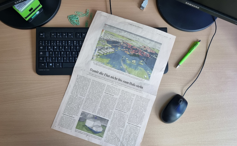
To provide effective decision support, alternative options need to be tested and analyzed. Users address "what if" questions to the system, e.g. "What happens if a dyke breaks?" or "Does it make sense to build a retention reservoir within the municipality?" The simulation software viscloud for flood and heavy rainfall provides clear answers to these questions by combining modules for simulation, analysis and visualization. It is the research group's most advanced solution. With personalized representations of flood risks for buildings and properties, the results of long-term research contribute to raising public awareness.
viscloud combines fast simulators for surface water, sewer networks and soil infiltration. The aim is to map the entire hydrological circuit with a single model. The team is currently working on integrating simulation models for a comprehensive analysis of climate change risks and adaptation measures. To do this, the researchers are combining thermodynamic heat simulations with hydrodynamic models for water.
viscloud supports over 75 cities and municipalities nationally and internationally in implementing preventive protective measures. In addition to many locations in Austria, there are also numerous locations in Germany (Hamburg, Cologne, Rhineland-Palatinate, and Lower Saxony), Denmark, Sweden and Norway.
Institute of Hydraulic Engineering and Water Resources Management, TU Wien
RWTH Aachen
University of Copenhagen, Department of Geosciences and Natural Resource Management
Stadtentwässerungsbetriebe Köln (AöR)
Hamburg Wasser
RIOCOM – Ingenieurbüro für Kulturtechnik und Wasserwirtschaft DI Albert Schwingshandl
Austrian Insurance Association (VVO)
Federal Ministry of Agriculture, Forestry, Regions and Water Management Austria (BML)
Oldenburg East Frisian Water Board (OOWV)
Ministry for Climate Protection, Environment, Energy and Mobility Rhineland-Palatinate
Head of Integrated Simulations Group, Integrated Simulations
waser(at)vrvis.at +43 1 908 98 92 509Behind our smart solutions and software are smart and driven people. Do you want to meet the team?
Integrating Simulation and Visualization
Hydrodynamic Modelling
Disaster Management
Cloud-based Visualization Systems
Flood Simulation
Design of Measures for Climate Change Adaptation
Design of Nature-based Solutions
Measures for Blue-green Infrastructure

In a research project for Rhineland-Palatinate, VRVis is creating a cooperative digital hydro twin for the German federal state to support the development of protective measures against heavy rain and river flooding.
The cities of the future rely on blue-green infrastructure: the University of Copenhagen, Henning Larsen and VRVis develop a software framework that combines hydrological modeling and 3D visualization for sponge city planning.
VRVis develops an interactive viscloud model for the OOWV (Oldenburgisch-Ostfriesischer Wasserverband) for simulating and visualizing regionally differentiated heavy rainfall events for the entire OOWV area.
As part of the research project WiCiD, VRVis is developing an interactive viscloud web application for the city of Gothenburg on behalf of DHI Sweden.
A high-resolution base model of the entire federal state of Rhineland-Palatinate makes heavy rain and flood simulations accessible to different user groups.
Within the framework of “AI for Green”-funded research project develops AI-based solutions aimed at optimizing free satellite data for monitoring agricultural areas of all sizes.
The Raincloud project's goal is to optimize and extend the simulation software viscloud to tackle the increasing challenges in water planning and disaster management in the face of climate change.
For many years we have been dealing with all aspects of hydrodynamic modelling. With our software viscloud we can model different scenarios and also offer this as a service.
We create a digital twin of a community and simulate weather events to identify high-risk buildings and infrastructure vulnerabilities.
The goal of HORA 3D is the development and maintenance of a publicly accessible web application for object-related visualization of the results of the HORA 3 research project.
viscloud's hydrodynamic simulations provide precise water level predictions at any point on a water surface in the "PegelAlarm" app.
Practical flood management with decision software viscloud.
Heavy rainfall events are increasing throughout Europe. In the EU project RAINMAN, VRVis has developed an interactive viscloud model to visualize the course and consequences of possible flood scenarios caused by heavy rainfall for the city of Graz.
Digital representations of the real world and digital twins are becoming increasingly important for planning, situation assessment and decision-making.
The HORA 3 project focuses on flood modelling for all rivers and streams in Austria. The results are detailed flood risk maps for different annual periods.
Decision support system for floods and inundations for the trading district of Shenzen, China.
Flood protection through simulation and visualization: Reducing the effects of floods and communicating measures to the public.


VRVis is a leader in hydrodynamic simulation of floods, heavy rain and slope water. We created a checklist for real life emergency situations in case of heavy rain and floods.

The flood simulation tool Visdom is the basis of special flood protection management plans for the Thaya region for a total area of more than 2,600 square kilometers.

As part of the research project WiCiD, VRVis is developing an interactive viscloud web application for the city of Gothenburg on behalf of DHI Sweden.

In a research project for Rhineland-Palatinate, VRVis is creating a cooperative digital hydro twin for the German federal state to support the development of protective measures against heavy rain and river flooding.